PORTLAND, Maine — This time of year, there’s no better place to be humbled by Mother Nature than in Maine. Saturday's storm was an all-day event from sunrise through sunset, and it never let up.
The precipitation started as snow statewide, and it was light by March standards. Then the temperatures rose a bit, but not above freezing, and it looked like a major, crippling ice storm was about to happen. The early spring sun angle delayed the freezing rain and was our saving grace—so we didn’t repeat the ice storm of 1998.
Once sunset hit and temperatures held below freezing without enough warm air to scour out the cold layer at ground level, we got the inevitable ice storm for the coastline. Meanwhile, in the mountains and foothills, feet of snow were piling up with 5 inches-per-hour snowfall rates during peak storm.


This was the most impactful statewide winter storm of the season (if we leave out the coastal flooding/rain/wind/waves storms we had).
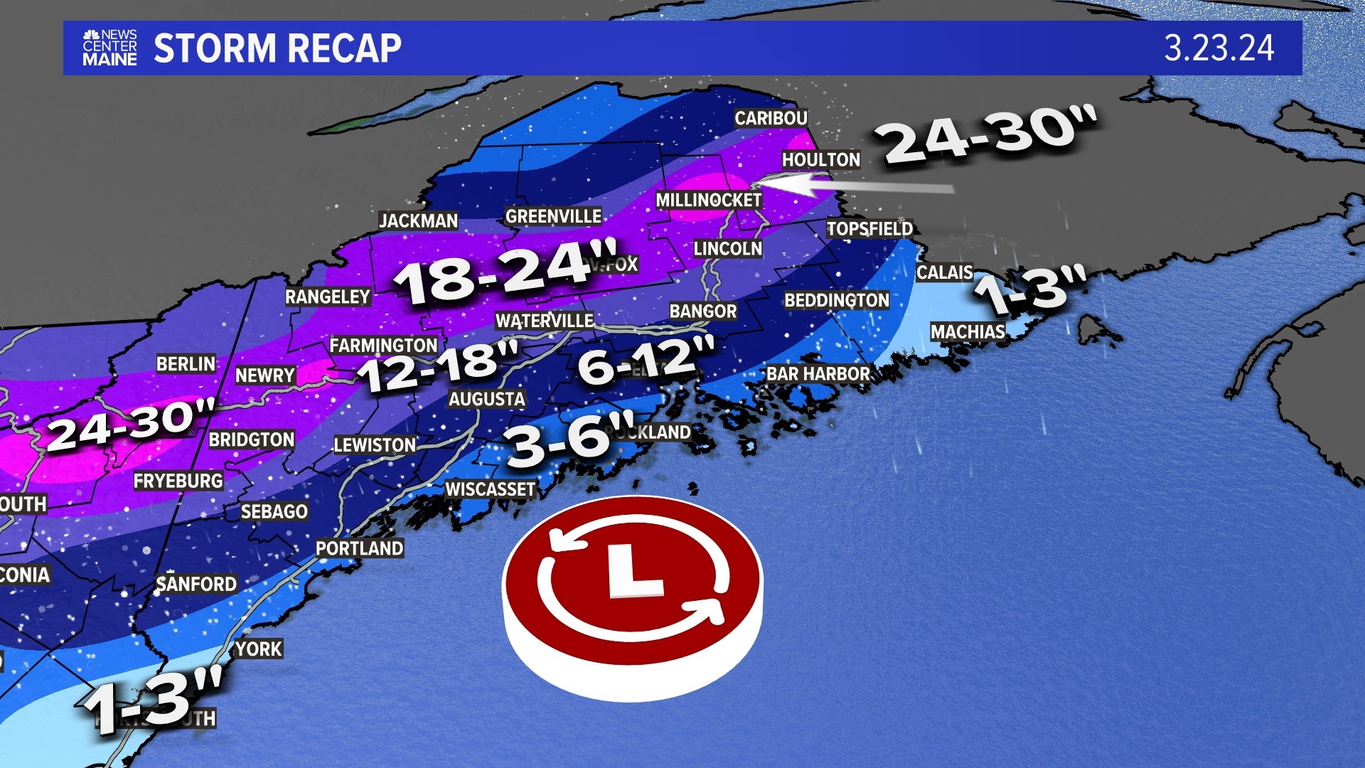
East Millinocket nearly hit 30 inches of snow.
New Gloucester measured a staggering 2.5 inches of sleet.
The Portland Jetport automated (ASOS) reported nearly three-quarters of an inch of freezing rain accumulation, or accretion if we are being nerdy.


During the day and night, we had all the wintry precipitation types you can imagine: snow, sleet, freezing rain, and rain.


Even though the freezing rain didn't cover a huge area, it was still the most impactful part of the storm, snapping branches and bringing down power lines for southern Maine and the midcoast.


Local storm reports were in the hundreds with snow, ice, and damage being reported all day Saturday, getting worse at nightfall.


We can’t forget about the incredible amount of snow this non-nor’easter produced. (We didn’t have the strong wind you expect from a nor'easter).
It's a detailed snow map showing the White Mountains of New Hampshire, western mountains and foothills of Maine, plus the central highlands and northern Maine getting clobbered.


Snow and ice totals for the Pine Tree State won’t be forgotten—or melt—anytime soon. It’s a saving grace for ski resorts coming in the 11th hour of "winter" but any amount of ice is not wanted at any time of the year.


We had freezing rain because a shallow layer of cold air, denser than warm air, held tough at ground level below the warm air riding up over top. The rain froze on contact once it became light enough and the sleet was gone. The sunset also had a big role to play without the high sun angle that kept surfaces just warm enough not to accumulate ice.
Another threat of freezing rain moves in for Tuesday. Keep checking back for updates.


Follow along for more weather blogs and pizza discussion.

