MAINE, USA — This nor'easter turned out to be one for the books! Well, in some spots. Portland ended the storm with a total of 17.6" at the Jetport. Gorham, which is less than 10 miles away, ended up with 24.1" of fluff.
If you take a trip to Bangor, don't expect a wintry wonderland. Reports out of Brewer, Bangor, and Old Town all topped out near 2" or 3".
Elsewhere in New England, snow totals made it into the 40" range. Historic for those towns, to say the least.
Now that the storm has passed, it's time to dive into the details and see what worked with the forecast, as well as what did not.
The Forecast

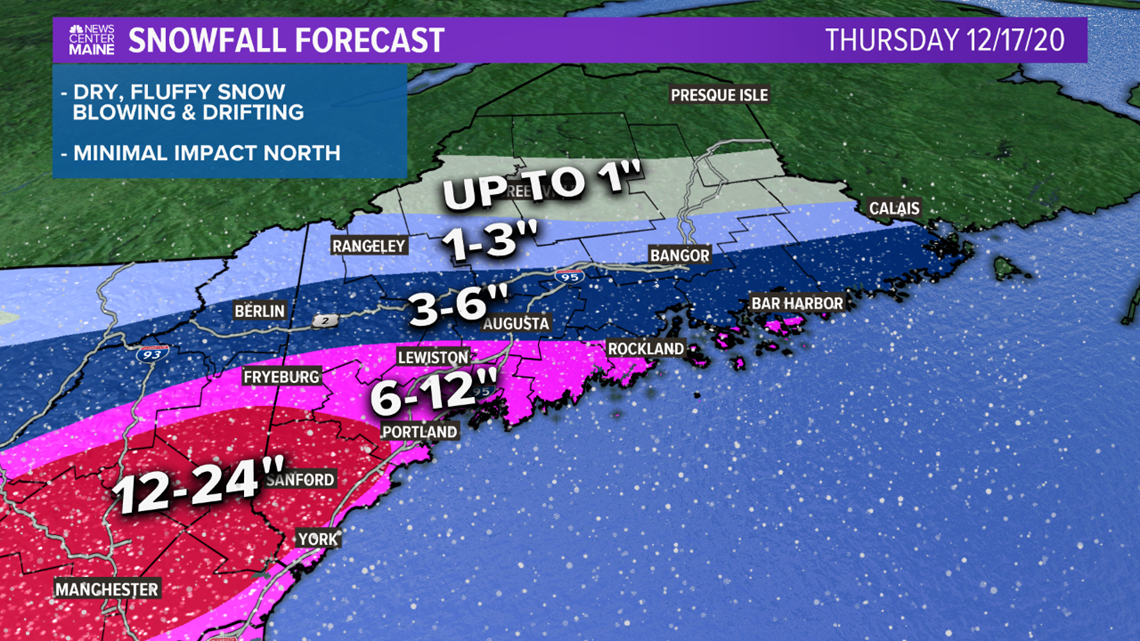
This was the final iteration of the snow map we issued, updated at 11 a.m. Thursday. Earlier versions showed less snow across Maine and can be found in our earlier blogs.
There was a large difference in forecast totals over a short distance, especially in western Maine.
The forecast called for over a foot in Kittery, with only 1-3" expected for the Route 2 corridor. That's a significant gradient.
The Midcoast was mostly locked in at 3-6", except for some isolated southern spots that were forecast to push 6-12".
Bangor was right on the 1-3" line, with less snow expected north.
What Worked
Forecasting a winter storm is a difficult and dynamic process.
Leading up to the event, models were still showing highly variable solutions. Pictured below is the GFS and all of its ensemble members.

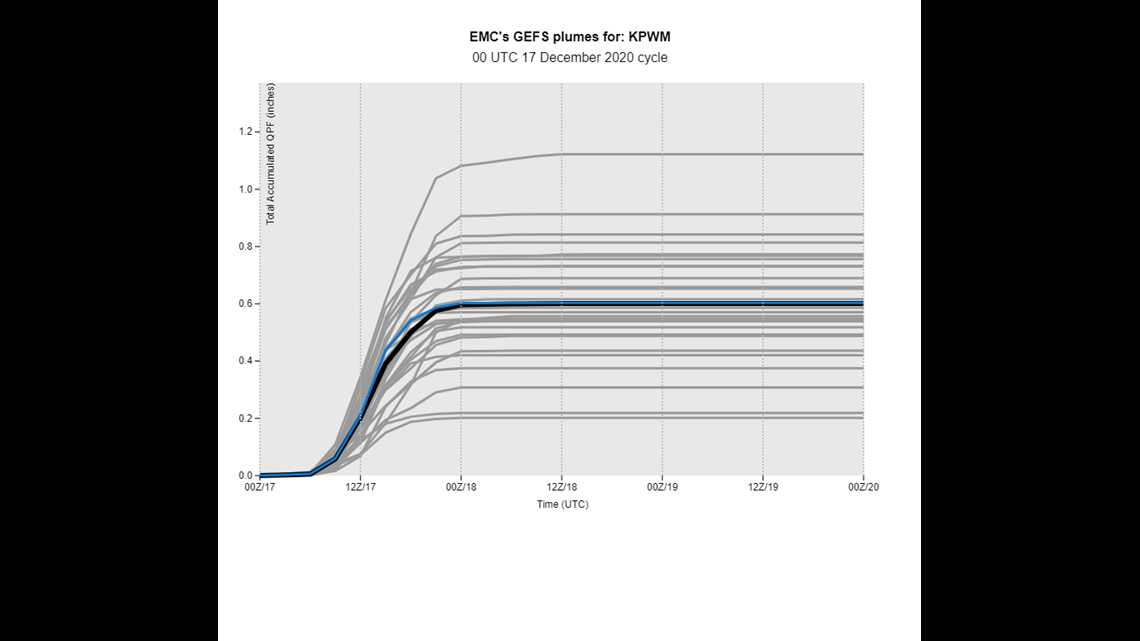
This is data from 7 p.m. on Wednesday, not even 12 hours before the snow was expected to start.
The variable shown here is called QPF, which stands for quantitative precipitation forecast. Don't mind the technical jargon here. This is just a fancy way of saying how much liquid was expected to fall.
For snow storms, the best way to figure out what actually fell for liquid is to melt some snow and see how much liquid is left over.
Other models, especially smaller scale models, showed that southern Maine was expecting roughly a half inch to an inch of liquid to fall within this storm.
It also highlights how moisture would struggle to make it into northern and western Maine since that wicked dry air was locked in place.
Most snowfall maps that you see use a 10:1 snow to liquid ratio. In other words, for every 1" of liquid QPF, it would be roughly 10" of snow.
Given the colder air in place, we figured a 10:1 or 12:1 ratio would work out well. This led to a forecast amount of 6-12" for York county to Portland, where 0.5-1" of liquid equivalent precipitation was expected. The higher numbers in southern York county are due to the fact that more moisture was expected, and thus higher totals.
Same idea goes for Bangor and most of the forecast area.
The timing and storm strength worked well for the forecast, as did the amount of liquid equivalent precipitation. So, why were the snow totals so much higher?
What Went Wrong
Ryan has a great tweet from Portland's snow totals breaking down what actually happened.
Despite the actual liquid amounts being pretty accurate (PWM with 0.84" in liquid), the snow ratios were much higher than expected.
A 20:1 ratio is something that snow lovers dream of, but isn't all that common in observation. This storm, of course, was the exception.
The other thing that really bumped snow totals up and ultimately allowed for the 2 foot totals in York county was a nearly stationary snow band. I tweeted about it yesterday afternoon.
I briefly mentioned something about snowfall rates approaching 2" an hour in my pre-storm blog, but this band was actually dropping anywhere from 3" to 4" an hour, if not a little more.
Given the persistent high snow rates, it's no surprise that these areas overperformed quite a bit. The full snow band from Pennsylvania to Maine is pretty evident on the snow map put together by the National Weather Service.

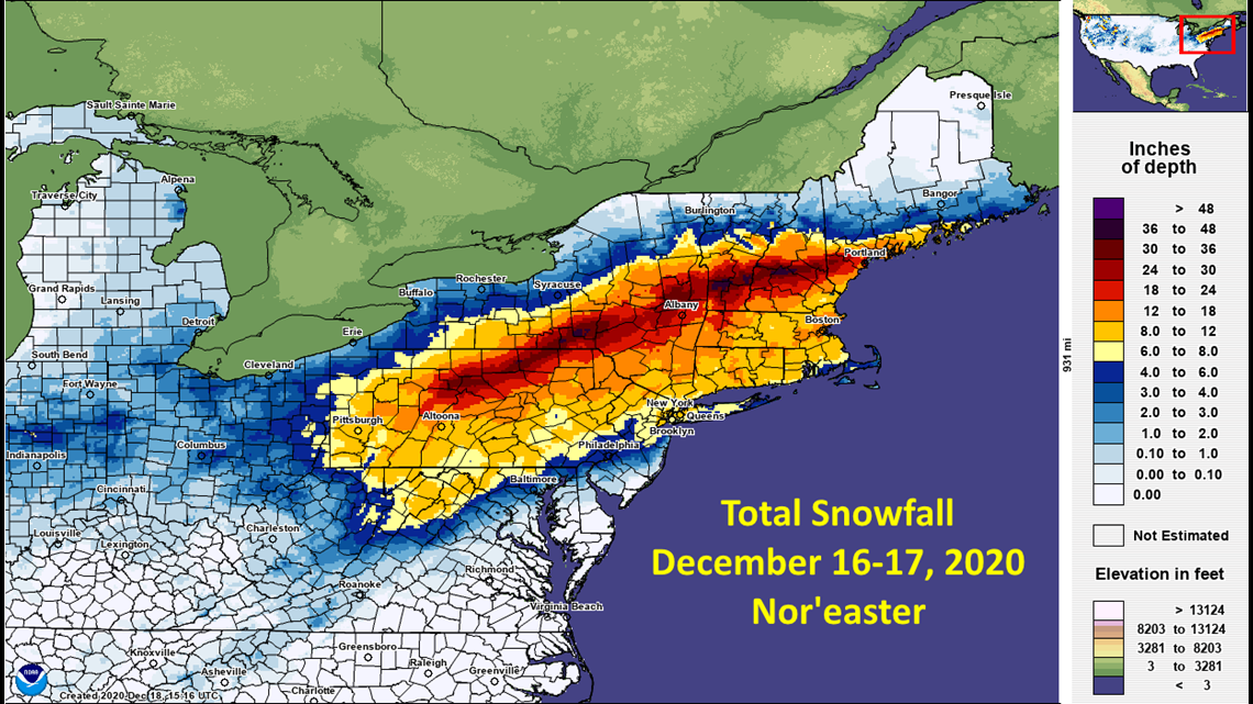
On the bright side, the higher snow ratios imply just how light and fluffy this snow was. Shoveling wasn't too bad and clearing off the car only required a little bit of elbow grease.
How It Stacks Up To Other "Big Ones"
Due to the fact that this was a southern Maine special, I'm going to compare the numbers to storm totals at the Portland International Jetport.

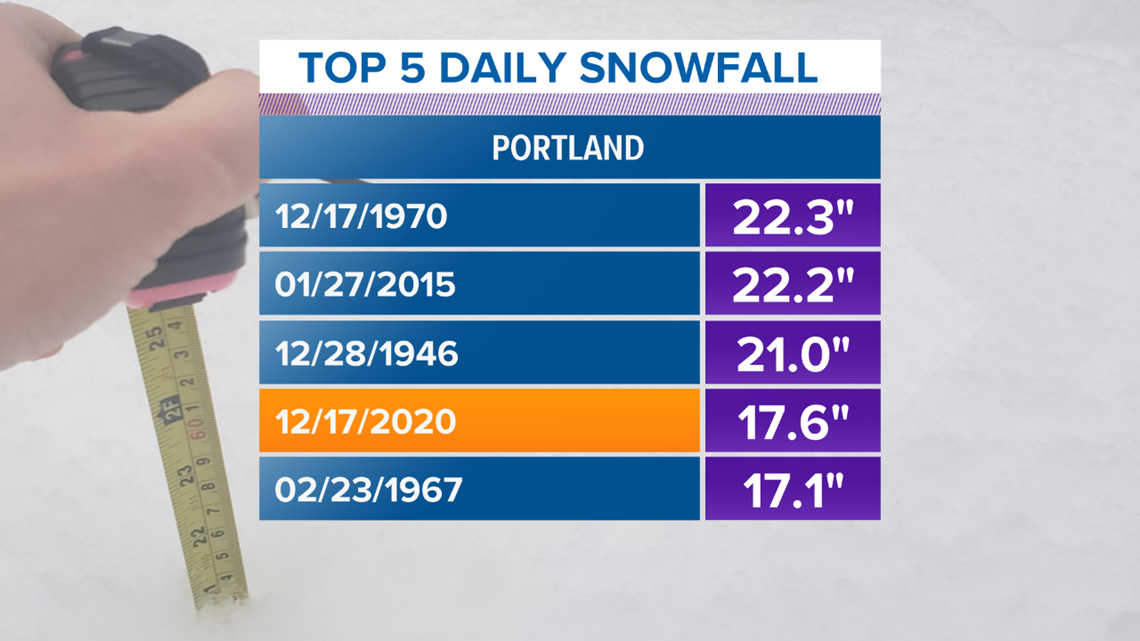
By daily snowfall metrics (midnight to midnight, snow recorded in one day), the storm ranked in the top five on record.
It shouldn't be a surprise that the January 2015 storm made this list. That was one for the books!

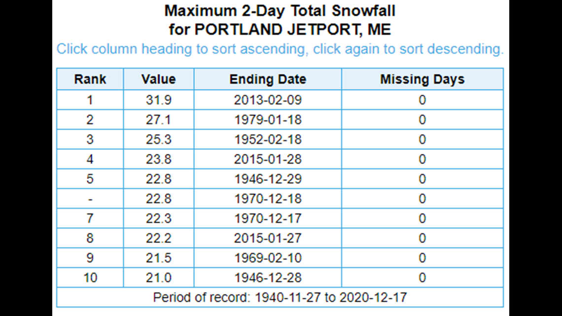
Given the fact that snow storms often take place over the course of a couple days, I wanted to dive into some of those numbers.
This storm, with a total of 17.6", does not even register in the top 10. Most of the other storms do have some pretty impressive totals, especially given that the February 2013 storm dropped over 30" of snow in Portland.
Who would've thought cold and snow records in Maine are pretty tough to beat?
For more forecast information and anything else pertaining to weather and/or Winnie, follow me on Twitter, @MikeSliferWX.

