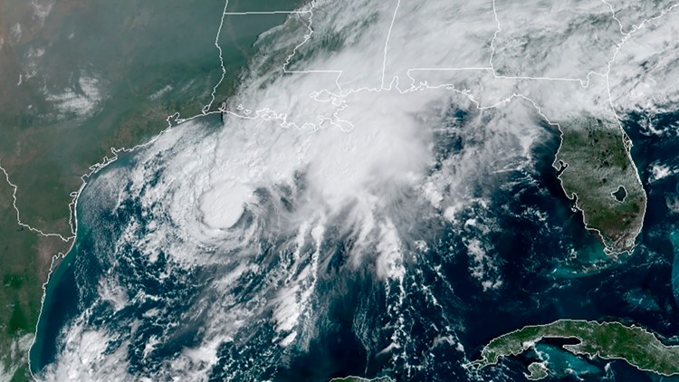
After churning out Tropical Storm Wilfred and Subtropical Storm Alpha, the hyperactive Atlantic continues to generate more named storms with the formation of Tropical Storm Beta.
This new storm has claimed the second letter in the Greek alphabet. Once the last name on the season's designated list is exhausted, Greek letters are used to identify tropical storms.
As Beta rolls toward the coast, a storm surge watch is in effect for Port Aransas, Texas, to High Island, Texas, and from High Island to Cameron, Louisiana.
A Hurricane Watch is in effect for Port Aransas, Texas, to High Island, Texas. Tropical storm warnings and watches also stretched across portions of the Gulf Coast from Texas into Louisiana.
The Atlantic once again became hyperactive on Friday with four tropical cyclones churning at once. Just on Monday, there were five tropical cyclones spinning simultaneously for the first time since Sept. 10-12, 1971. That number dropped to four on Tuesday after Rene dissipated, leaving Paulette, Sally, Teddy and Vicky for a time.
As of 7 p.m. CDT Saturday, Major Hurricane Teddy, Tropical Storm Wilfred and Tropical Storm Beta were all still on the prowl. Subtropical Storm Alpha lost wind intensity and became a remnant low over Portugal very early Saturday morning, local time.
A strong disturbance that was spinning over the central Atlantic claimed the last name on the season's designated list, Wilfred, when it strengthened into a tropical storm on Friday at 11 a.m. EDT, according to the National Hurricane Center (NHC). It became the earliest-21st named storm on record in the Atlantic basin, beating out Vince, which formed on Oct. 8, 2005, according to Philip Klotzbach, a meteorologist at Colorado State University.
A few hours later, Subtropical Storm Alpha formed right along the coast of Portugal during Friday afternoon.
Alpha set a new record for the earliest 22nd-named storm to develop in the basin, forming nearly one month earlier than the previous record holder for that title, the notorious Wilma from 2005. Wilma did not become a named storm until Oct. 17 that year, but went on to strengthen into the most intense hurricane ever recorded in the Atlantic at Category 5 strength, packing winds of 185 mph and a central barometric pressure of 26.05 inches of Mercury (882 millibars).
Beta wrote a new page in the record books for the 23rd-named tropical storm in the Atlantic, replacing Alpha from 2005, which formed on Oct. 22 and was first-ever storm to be named a Greek letter.
Meteorologists had been monitoring the disturbance for over a week before it developed into Tropical Depression 22 on Thursday, with maximum sustained winds of 35 mph. By Friday at 7 p.m. CDT, the system strengthened into Tropical Storm Beta, with maximum sustained winds of 60 mph and was nearly stationary, with little movement. As of 4 a.m. CDT on Sunday, the storm was located 205 miles southeast of Galveston, Texas.

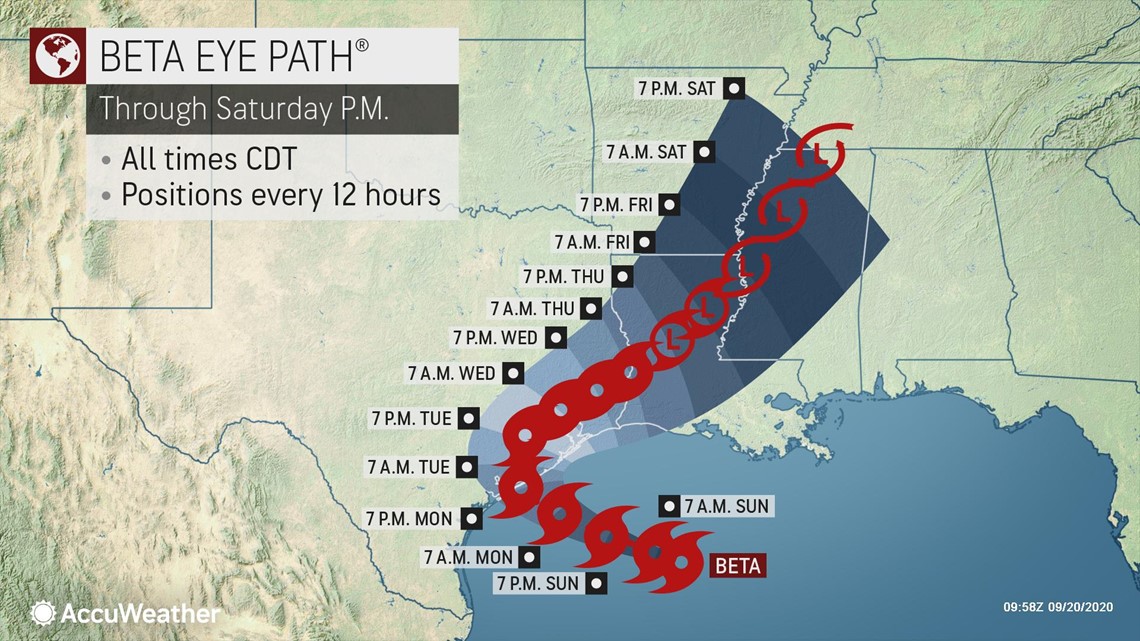
Weak steering breezes will result in the tropical system over the Gulf of Mexico to remain nearly stationary or meander over the open water over the next few days.
A general westward drift toward Texas is expected into early week. The storm is expected to wander toward the Texas coast before turning back northeastward toward Louisiana.
"Tropical Storm Beta is a reminder that hurricane season is still in full swing," Houston Mayor Sylvester Turner said in a media release on Friday. "We will be monitoring this storm's development closely over the next few days as it continues to strengthen in the Gulf. Now is the time to prepare. Stock your emergency kit, refill prescriptions and monitor Houston OEM's channels for official updates."
A slow-moving storm such as this can disrupt oil and gas production in the western Gulf of Mexico for several days, AccuWeather meteorologists warned.
"We are getting to the time of the year where it is difficult, due to prevailing steering winds, for tropical systems to move onshore in Texas," according to AccuWeather's top hurricane expert Dan Kottlowski.
"However, we are not fully into that part of the season just yet, and we will have to monitor the behavior of those steering winds and how much an area of high pressure builds across the central and eastern U.S., which could partially block the northward path and perhaps steer the system toward the Texas coast," Kottlowski cautioned.
"How strong the system gets may hold the key as a stronger tropical storm tends to poke higher up into the atmosphere and might get steered westward toward Texas, while a weaker system may hover in the lowest part of the atmosphere, where it avoids the stronger winds aloft and then hovers over the Gulf for days," Kottlowski said.
If Beta does makes landfall as a named storm in the United States, it would be the ninth system to do so this season.

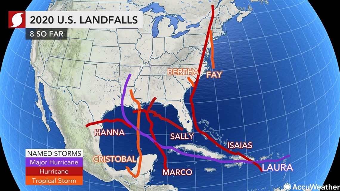
The slow movement of the system has raised alarms among AccuWeather forecasters. In 2017, Harvey unloaded up to 61 inches of rain as it spent days over eastern Texas. Even though this system is not expected to reach the strength of Harvey, it will have the resources to produce torrential rainfall.
"The slow movement of Beta means that it is going to fling large amounts of rain toward the coast for several days," explained AccuWeather Meteorologist Brett Rossio. "If this rain ends up being particularly persistent over a single area, it could cause serious flooding issues, even if the center of Beta is still well offshore."

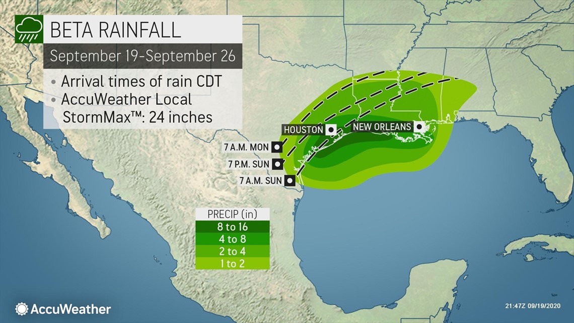
The slow movement of the system is likely to continue, no matter which direction it wanders. If the system wanders to right along the coast, then rainfall could be measured in feet instead of inches.

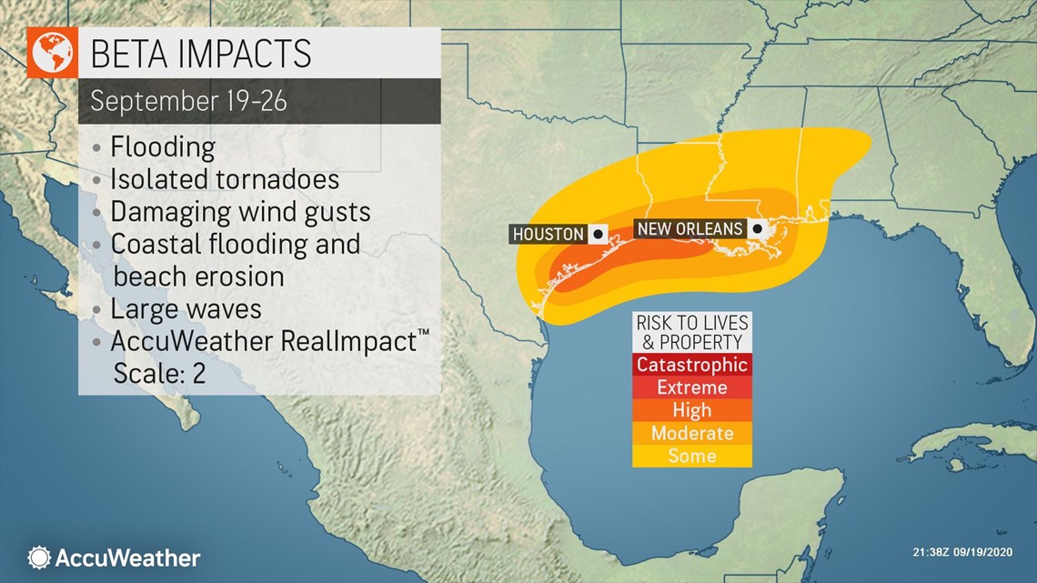
Some moisture will be sheared off to the northeast of the budding storm, which will produce heavy rainfall in the Southeast states. Saturday morning heavy rain from Beta was already dousing parts of southeastern Louisiana, several hundred miles northeast of the center of the storm.
"Any torrential rain could add to the flooding problems from Sally, which are still ramping up as runoff from urban and small streams works into the larger river systems in the Southeast," AccuWeather Meteorologist Courtney Travis said.
Parts of southwestern Louisiana that were devastated by Hurricane Laura will also see some disruptive wind and rounds of rain that could hinder ongoing recover efforts.
"Texas could take a reasonable amount of rain, while areas farther to the east in the South would have trouble," she added.
As Beta meanders along the western Gulf Coast, gusty winds will also persist for days near the western and central Gulf coast. A large area of 40-60 mph wind gusts is expected, with higher gusts of 60-80 mph and an AccuWeather Local StormMax™ of 90 mph expected where Beta initially approaches the coast in Texas.

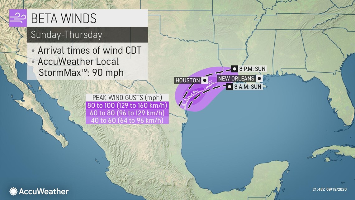
"Gusty winds and rain could reach the south coast of Texas as early as Sunday," Kottlowski said.
"Some of the outer bands spinning onshore over the next several days could also contain locally stronger wind gusts," Rossio added. "Water spouts and tornadoes will also be a concern for areas near the coast north and east of the center of Beta."
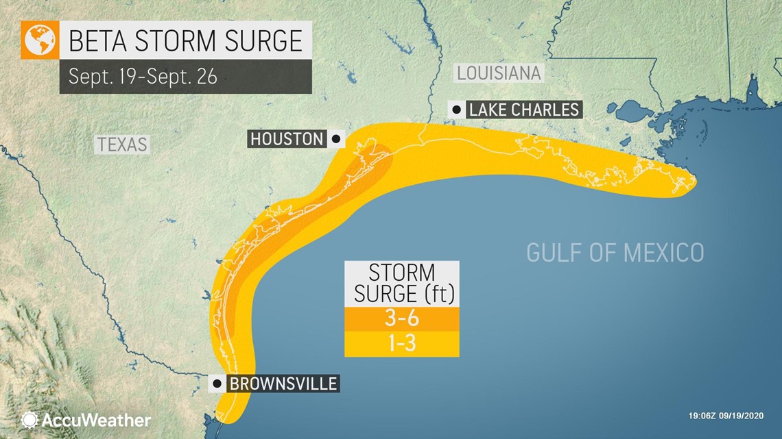
The storm will also get large enough and strong enough to create some storm surge along the western and central Gulf coast, as well as rough seas, pounding surf and dangerous rip currents over the Gulf of Mexico.

With months still left in the Atlantic hurricane season, more Greek letters are likely to be used. This past week, AccuWeather meteorologists upped their 2020 season predictions for the number of total storms to 28, which would tie the record number of named storms in the basin set in the notorious 2005 season.
Keep checking back on AccuWeather.com and stay tuned to the AccuWeather Network on DirecTV, Frontier and Verizon Fios.


