
AUGUSTA, Maine — A new report from a national climate-focused nonprofit ranked Maine top in the country for the policies the state has for addressing climate change and how the state acts on those policies.
The 2023 State of the Beach report from the Surfrider Foundation gave Maine an 11 out 12 possible points, tying it with California and Maryland. The three states got the same grades in the previous year's report, too.
The report grades 30 states and the territory of Puerto Rico on comprehensive laws and policies to protect our nation’s beaches from: coastal erosion, sea level rise, and poorly planned development.
"Maine has really effective policies in place in terms of how the state is responding to climate change and coastal erosion," Isabella DeFrancesco, Surfrider Foundation Northeast's regional manager, said.
DeFrancesco said Maine does well in planning for sea level rise. In 2021, Gov. Janet Mills signed HB 1572 into law, which requires state agencies to incorporate 1.5 feet of relative sea level rise by 2050 and 4 feet by 2100 into the administration of those laws and rules.
That effort is part of the work by Maine's Climate Council, a team of "scientists, industry leaders, bipartisan local and state officials, and engaged citizens to develop a four-year plan to put Maine on a trajectory to reduce emissions by 45% by 2030 and at least 80% by 2050."
New seawalls and the extension of existing seawalls on beaches are illegal in Maine, due to their impacts on the ecosystem.
"They actually block the natural flow of sand to the beach and cause more erosion," DeFrancesco said.
The Surfrider Foundation advocates for nature-based solutions to protect from coastal damage and restore dunes after erosion: fighting nature with nature.
"Even if it's just in one small stretch of area, it really is going to be the solution towards going forward to fighting climate change," DeFrancesco said.
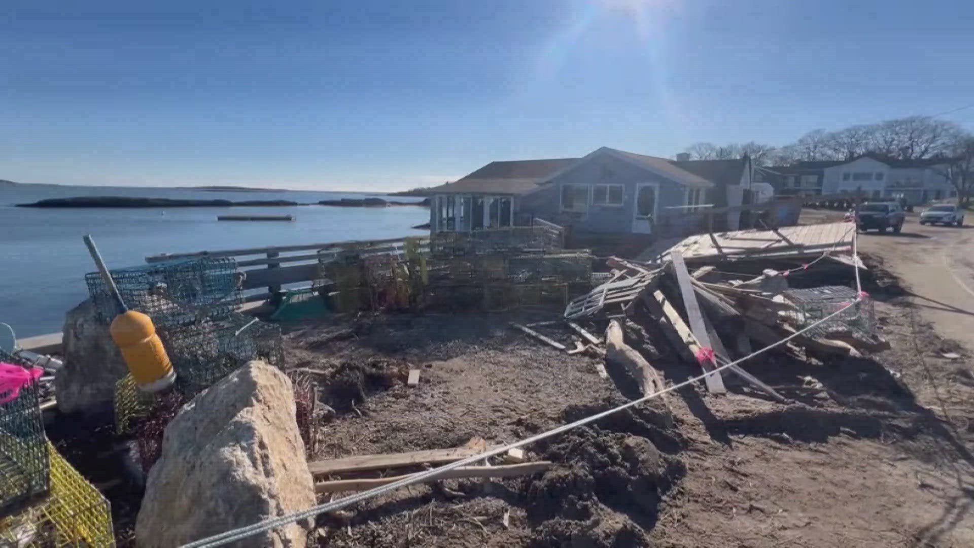
While Maine earned top marks in 2023's report, the state's coastline has already been taking a beating in 2024. Two powerful and historic storms in January and one in March caused flooding during a king tide with extensive damage to roads and the working waterfront.
Peter Slovinsky, a scientist with the Maine Geological Survey, said Maine is looking at the state's vulnerabilities and what the responses should be. Those include working with the National Oceanic and Atmospheric Administration and the Maine Department of Transportation to develop dynamic flood models for Maine's coast.
The high-resolution, dynamic, and probabilistic model of flood risk along the Maine coast from storm events and projected sea level rise will be called the Maine Coastal Flood Risk Model, or ME-CFRM. The model will take advantage of a new NOAA LiDAR dataset that will provide consistent, high-quality topographic and bathymetric data covering nearly the entire coast of Maine.
Scientists are currently collecting the LiDAR data. NOAA is scheduled to release it starting in mid-2023. The DOT expects preliminary ME-CFRM output to be available beginning in the spring of 2024, with final model results ready to be shared with the public by the fall of 2025.
"You can answer the question of, 'OK, in 2050, after X amount of sea level rise, what's the percent chance that this section of coastline is going to get wet?'" Slovinsky said.
He also said York and Cumberland counties are set to adopt new FEMA flood insurance rate maps for the first time since 2006.
"Those maps are put out to inform people about the risk associated with having flood insurance, but they're used for a lot more than that, and they're one of the best tools we have out there right now to look at existing vulnerability," Slovinsky said.
One vulnerability the January storms exposed was the weakness of working waterfront infrastructure and homes built on the coast. He said towns will have to decide whether to rebuild or retreat. But Maine's commercial fishing industry may only be able to do the former: rebuild.
"That infrastructure has to be along the water, but that infrastructure also has to be made resilient to the conditions we currently see and will potentially see in the future," he said.
Slovinsky said the state will allow piers and wharves damaged in the January storms to be rebuilt up to four feet higher than they were before the storms, by using simple permits. He said many of them were not built to today's floodplain standards.
Cities like Scarborough and Cape Elizabeth are considering removing a portion of Sawyer Road, which connects the two towns and routinely floods. Plans for the project call for removing more than 1,000 feet of the road that cuts through the marsh. The road would have a public turnaround on each side. Nearly $1.6 million of the project would be covered by grant money. Both towns would need to pay $180,000 to cover the rest.
The City of Saco has removed or rerouted utility lines including gas, electric, and sewer along the frequently flooded Surf Street in Camp Ellis.
Slovinsky and Surfrider are on the same page about protecting the coast, saying that nature-based solutions are critical.
"These recent storms really bring to light that the effects of climate change are happening really fast," DeFrancesco said. "This situation isn't simply a situation where we can build back higher or stronger. Mother Nature is too strong, and we have these intensifying storms that are going to be fueled by climate change."